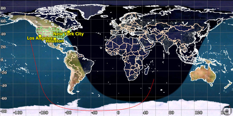
The 2D map Viewpoint type allows users to configure an output window displaying the desired objects on an equidistant-cylindrical map of the desired celestial body. A Map command can be used to create a 2D map view, or a ViewWindow object with a 2D map Viewpoint can be used. The following is a list of the configurable options for a 2D map Viewpoint.
•Reference Frame •Mapped Body •Map width and height •Map center point - either latitude/longitude coordinates, or the subsatellite point of a specified Spacecraft object •Display settings for the latitude/longitude grid |

Sample 2D Map in FreeFlyer
The script example below shows how to create a custom 2D Map Viewpoint centered on 70 degrees West, 35 degrees North on the Earth's surface, and add it to a ViewWindow. We are also showing how to turn on latitude and longitude grid lines, set the label locations, and adjust the label font.
// Create Map Viewpoint Viewpoint MapViewpoint; MapViewpoint.ViewpointType = "map"; MapViewpoint.ViewpointName = "Map View"; MapViewpoint.MapView.ReferenceFrame = "body fixed"; MapViewpoint.MapView.Body = Moon.ObjectId; MapViewpoint.MapView.CenterLongitude = 230; MapViewpoint.MapView.CenterLatitude = 5; MapViewpoint.MapView.Width = 300; MapViewpoint.MapView.Height = 90;
MapViewpoint.MapView.ShowLatitudeLongitudeGrid = 1; // Turns Lat/Long grid on MapViewpoint.MapView.LatitudeGridLabelLocation = 2; // Sets Latitude grid on right MapViewpoint.MapView.LongitudeGridLabelLocation = 3; // Sets Longitude grid on bottom and top MapViewpoint.MapView.LatitudeGridLabelFont.Bold = 1; // Configure Latitude grid font MapViewpoint.MapView.LongitudeGridLabelFont.Bold = 1; // Configure Longitude grid font
// Add Viewpoint to a ViewWindow and activate it ViewWindow ViewWindow1({Spacecraft1}); ViewWindow1.AddViewpoint(MapViewpoint); ViewWindow1.ActivateViewpoint(MapViewpoint.ViewpointName); Update ViewWindow1; |
See Also
•Map Command
•MapViewpointOptions Properties and Methods