Description
Returns the elevation angle of the argument as seen from the reference object.
Timing Precision Mode
This page describes functionality in nanosecond timing precision mode.
Click here to see the documentation for this object in millisecond timing precision mode.
Overload List
Signatures |
Return Value |
Description |
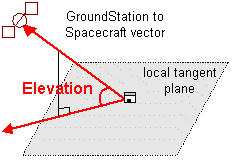
Returns the angle between the GroundStation-to-vehicle vector and the GroundStation's local horizon plane, which is tangent to the central body's reference spheroid. The Earth uses the World Geodetic System (WGS) 1984 reference spheroid. |
||
GroundStation.Elevation(CelestialObject celestialObject, TimeSpan epoch) |
Returns the angle between the reference-to-target vector and the x-y plane of the reference object in the GroundStation body frame. |
See also
Coverage and Contact Analysis Guide